Posted April 14, 2015
by Jean Frost, Preservation Vice-President
 What happens when historic preservation goals clash with transportation objectives? WAHA and St. John’s Cathedral co-sponsored an informational meeting in December, bringing officials from The California Department of Transportation (Caltrans) and METRO together with community representatives and preservation advocates to learn more about Caltrans’ plans to erect a “Flyover” ramp that would stand perilously close to numerous historic resources and housing units, and above the Expo Light Rail line.
The California Department of Transportation (Caltrans) District 7 is proposing an Interstate 110 Transit Way Connector Project I-110 HOV/HOT off ramp to Figueroa Way (EA 27800.) The proposal would cost at least $40 million –– $7 million now, just to prepare reports and assessments related to its environmental clearance, and another $30-plus-million to actually design, engineer and build it. Caltrans (and Metro) had thus far pursued this proposal with little or no public input, which is why we brought many of the stakeholders together to meet with the transportation officials.
By meeting’s end, it was clear that the transportation staff was more interested in reducing vehicle wait times by, at best, a minute or two, while not taking into account the major impacts such a project would have on the people and places adjacent and below it. Concerns include not only visual impacts – which would be tremendous – but, among other concerns, also air quality and noise impacts on adjacent residents, workers, students, and worshippers, along with worries about safety in the face of a potential major earthquake.
Moreover, the proposal is puzzling given that most urban-planning experts are now trying to envision ways to move people out of private vehicles and into public transportation. One meeting participant cited studies that show that projects like this actually may encourage more people to drive by themselves in their personal vehicles, and thus the project becomes counter-productive as the now-more-crowded freeway slows down again.
Background
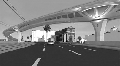
The proposal involves construction of a two-lane flyover ramp that would cross St. John’s Cathedral parking lot, pass within seven feet of a mini-mall on Adams and Figueroa and be approximately forty feet high, landing traffic at Figueroa and 23 Street. Having defeated a similar (but lower in height) proposal in 1990, many in the community are flabbergasted that this has come back to life. As noted by Jim Childs in the November WAHA Matters newsletter: “This noxious phenomenon has now been embraced by the California Department of Transportation (Caltrans) District 7 with its revitalized proposal” - only this time higher and bigger. The height of the flyover next to the church would be approximately 43.6 feet; at some locations, 50 feet; highest point will be 71.8 feet above grade.
WAHA and St. John’s Cathedral (which was informed by Caltrans as a “courtesy” in October of the project’s revival) sponsored the informational meeting on December 3 and invited Caltrans and affected stakeholders to participate in a discussion of the project. In attendance were representatives from St. John’s Cathedral, the North University Park Community Association (NUPCA), the Los Angeles Conservancy, Adams Dockweiler Heritage Organizing Committee (ADHOC), United Neighborhoods Neighborhood Council (UNNC), North Area Neighborhood Development Council (NANDC), California Preservation Foundation (CPF), Caltrans, Orthopedic Hospital, the Los Angeles County Metropolitan Transportation Authority (Metro), Figueroa Corridor Business Improvement District (BID), Mount St. Mary’s University, the University of Southern California (USC), the National Trust for Historic Preservation, State Assembly District 59, and WAHA
Caltrans, according to their fact sheet, “in cooperation with the Los Angeles County Metropolitan Transportation Authority (Metro), is currently preparing an Initial Study/Environmental Assessment and a Project Report to analyze improvement alternatives to the current termination of the NB I-110 HOV/HOT lanes at Adams Blvd, which currently presents a particularly challenging bottleneck.” This study is funded by Metro and federal funds for $7 million. WAHA’s Preservation Committee believes a great deal of the seven million taxpayer dollars could be saved by understanding the futility and ineffectiveness of what is being proposed and stopping the project now.
Since the project involves federal funds, consultation has been initiated under Section 106 of the National Historic Preservation Act (NHPA) and compliance with Section 4(f) of the Department of Transportation Act will also be required.
The project would undeniably cause significant impacts to the large number of historic resources adjacent or near to the project site and likely result in an adverse effect. Those historic resources include but are not limited to St. John’s Cathedral, St. Vincent’s Cathedral, the Automobile Club of Southern California, the Chester Place Historic District, University Park Historic Preservation Overlay Zone, the St. James Park National Register District, the Twentieth Street National Register District, the Woolen Mills Zanja, and the Stimson Mansion.
But Caltrans is coyly denying its impacts: “The Division of Environmental Planning is currently in the process of preparing technical studies for this project. Based on the information we have at this time, no direct adverse effects on historic properties are expected to result from construction and implementation of the proposed project. The project may have indirect setting effects on the Cathedral, but we cannot be certain at this point in time. “
Cannot be certain at this point? May have indirect setting effects? One need only walk to the nearby 28th Street and Flower flyover ramp and stand near the pillars where you cannot hear anyone standing next to you due to the freeway-generated noise; then imagine these lanes being forty feet above you. Place this near St. John’s, and you have some idea of what the effect will be.
Caltrans was asked for a visual mock-up or model of what is being proposed for people to see. Caltrans responded that because it’s early in the process, they cannot provide a model or visuals. A representative from Metro said a visualization was possible “within the next month or so.” Subsequently, although WAHA has repeatedly requested it, no such model or representation has been provided.
Previous Comments
While Caltrans may believe this is early in the process, for those of us who commented on the Notice of preparation (NOP) in February 2013, or viewed a similar proposal in 1990, it is not early in the process.
Did Caltrans ignore the comments to the NOP in February 2013, to wit: “The Caltrans proposal would not only degrade the beauty of our historic building, it would result in an unacceptable level of noise, vibration and environmental pollution directly affecting our property and environs” (letter from St. John’s Cathedral). And as NUPCA stated: “An elevated bridge would certainly have incompatible massing and scale adjacent to a roster of historic resources.” Many other organizations, including WAHA, made similar comments. And as ADHOC noted, the idea of a ramp to 23rd and Figueroa in 1990 was “rejected in part because of the significant negative impacts to the historic resources of University Park. All of the project alternatives that proposed flyover HOV ramps above Adams Boulevard were also rejected for that reason.”
It appears that there is no institutional memory at Caltrans in spite of the clearly demonstrated outcry. The Caltrans response is “we cannot be certain at this point.” Indeed, the current environmental team initially appeared to not even know that individuals and organizations had provided written comments two years ago. So we are left with the burning question: Why is $7 million in taxpayer money being spent to demonstrate what was and is obvious to stakeholders, namely that this project cannot be mitigated nor can it be justified to go two blocks.
What is Achieved by the Project?
In their statement of facts Caltrans narrowly focuses on data that indicates that the current terminus off ramp is “a particularly challenging bottleneck.” They state, “The project would alleviate the congestion and reduce the queuing and delay on the HOV/HOT mainlines and Adams Blvd. off-ramp connector.” This view is myopic and short-sighted. You may relieve the bottleneck at this location on the freeway, but when you move traffic two blocks you dump the traffic at 23rd Street and Figueroa then what does it do? You’ve just moved the pain two blocks further to an already challenging intersection. The analysis essentially put its head in the sand and ignores the impacts on 23rd and Figueroa.
What do you prove when you dump the traffic there to save some seconds? According to their statement of facts: “The proposed elevated HOV/HOT off-ramp connector on the Northbound I-110 between 28th street (PM 20.58) and Figueroa Street Overcrossing (PM 20.92) would bypass the bottleneck intersections at Adams Blvd and Flower Street and eliminate the delay by providing the direct access to Figueroa Street.”
But then what does their own data show? The issue of the congestion and reducing the queuing and delay on the HOV/HOT mainlines and Adams Blvd. off-ramp connector is focused on “peak service hours, AM and PM.” The rest of the time, no problem occurs and the off ramp functions as it was envisioned. At the meeting, Caltrans presented graphs of four intersections: the I-110 Adams Boulevard off ramp, Flower and Adams, Figueroa and Adams, and Figueroa and 23rd and what would be achieved based on seconds of delay at each intersection. What their own data revealed is, if this is built, the improvements are negligible. Based on Caltrans’ own graphs, at the four intersections, in AM peak hours, two intersections remain the same, one improves, and one actually gets worse. In the PM, two show minor improvement, one stays the same and one gets worse. This does not solve Los Angeles’ real traffic issues and sacrifices much of what is the neighborhood character.
The Figueroa Corridor Streetscape project (“My Figueroa”) has been designed to encourage pedestrian activity and multiple “modalities” (e.g., bicycles, busses, light rail, etc.) It eliminates a traffic lane for traffic going south from Figueroa and Adams placing value on a pedestrian shopping district. How can you reconcile the effort to calm traffic south of Figueroa and adding traffic north? Shouldn’t value be placed on the cohesion and pedestrian accessibility of the community in University Park?
Increased Capacity–Increased Tolls
At the information meeting, Caltrans denied that the Flyover would add to the capacity of the HOT lane. An attendee said, “Adding capacity to a roadway increases the number of drivers on that roadway. Is Caltrans looking at Public Transportation alternatives?” “We are not adding capacity,” insisted a Caltrans team member.
Yet in their own fact sheet list of benefits Caltrans states: “Increasing capacity at this location is key to ensuring the HOV/ HOT lanes can serve additional toll users and reduce the delay.”
One attendee commented: “Studies show increasing capacity in one mode of transportation to solve a crowding problem simply results in more people using that mode of transportation Therefore the proposed change/addition to the freeway is also creating the probability of more vehicular traffic. If Caltrans makes it easier to drive, people will choose to drive. Different modalities (carpools, busses, metro) need to be improved and developed, not increasing ease of use on freeways.”
Next Steps
WAHA and St. John’s Cathedral are mobilizing a coalition of concerned and affected parties in an effort to achieve some transparency on what is happening and gather information. If you have ever stood under the “El” in New York or Chicago, you will have some idea of the aesthetics and quality of life involved in this proposed action. Needless to say, no one built elevated transit on Park Avenue. The blight was funneled off to the outer boroughs. Having had a freeway intersect this community many years ago, WAHA is ready to draw the line against further disintegration of our environment in addition to recognizing the obvious negative impacts to this historic community.